Lead Forecaster Daniel Crawley
Good Saturday morning to everyone,
The significant rainfall associated with former Hurricane Nicole has left the United States and we are going to abruptly move on from tropical weather to a taste of winter.
Your Saturday is going to feature one last relatively mild day as the cold air is still west of the Appalachians. Westerly winds will downslope today and with some sunshine we will reach the mid to upper 60’s.
The big changes occur tonight as much colder air filters in. Everyone will be in the 30’s by Sunday daybreak…and this is only the start of a prolonged cold wave that May span the entirety of next week.
Synoptics…
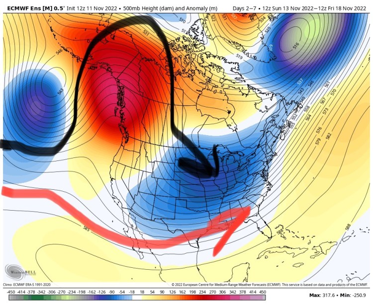
We have a major shift in the pattern across North America. A massive ridge will form across Alaska and stretching down into the Pacific Northwest. That serves to dislodge cold air from near the Arctic Circle down into the United States.
That is already happening and will move east into the Eastern US. You also notice how a split flow pattern evolves from this. Pacific energy might undercut the ridge at times allowing storm systems to take the southern route.
If it was a month to two months later, we would likely see the makings of a winter storm evolve from this pattern. But it’s still November. That said, this is the secondary pattern we made reference to in the Winter Outlook posted earlier in the week.

The key this go-around is the cold air that is going to overtake the country for Sunday and all of next week. As the blocking ridge holds tough, a couple different surges of cold air, colored in blue and purple on the map moves in from the northwest.
As you can see on the Meteogram, colder than normal air locks in and does not retreat. For reference, the averages for Marion, Morganton and Lenoir is 60 and 38. In Lincolnton and Shelby the averages are 62 and 39…we will not be very close to those numbers during the upcoming forecast period.


We feel with some confidence that two precipitation events will occur next week. One being on Tuesday (higher forecast confidence) and another being around next weekend (lower confidence).
That should bring some more rain to the area which after this weeks rain will further help improve the drought.
One area where the air might be cold enough for frozen precip could be above 3500 ft in the mountains. Guidance is starting to pick up on that for Boone.

For the ski slopes this next 7-12 days leading up to Thanksgiving could be very beneficial as snowmaking will begin.
For us here in the Foothills and Piedmont, the cold is the story. Temps coming up will be more reminiscent to something around Christmas and thereafter.
