
Lead Forecaster Daniel Crawley
Good Monday morning, we continue to monitor the next storm system to impact our region starting early tomorrow morning.
Cold air has overtaken a large section of the United States. This morning featured temperatures in the low to mid 20’s across the Foothills and Western Piedmont.
Our next storm system is currently located across the Southern Plains and will quickly move to the northeast over the next 24-36 hours.

Cold, dry air will be in place at the surface, Dewpoints by late tonight will be in the mid to upper 20’s across Western North Carolina. Clouds will increase quickly tonight and by around daybreak moisture will begin to invade the coverage area from the southwest .

The combination of cold dry air with warmer, moist air overrunning could lead to a short window on Tuesday morning where frozen precipitation in the form of light freezing rain or sleet pellet might fall.
With the Monday 12z guidance coming in, we see no significant changes. The best chance of seeing a brief window of wintery weather is along the Blue Ridge Parkway and escarpment. Locations like Hickory Nut Gorge, Little Switzerland, Linville Falls, Jonas Ridge, Globe and Edgemont.
And with the cold, dry air in place, a brief sleet pellet at onset of precipitation is possible in the lower elevations of the foothills, generally along and west of NC 18 / US 64 from Lenoir to Lake Lure.
Right now the timing of winter weather looks to be in the 4 am to 9 am timeframe on Tuesday. Impacts to the region should mainly be confined to a glaze of ice on trees and elevated objects.

Below is a radar loop for the Southeast over the next 24-36 hours. After the threat of freezing precipitation ends, the rest of Tuesday will feature cold, raw conditions with some locations not reaching the 40 degree mark until Tuesday evening.
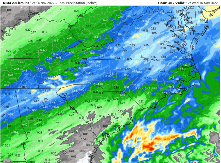
This looks to be another decent rain maker for the Western Carolinas as totals should range from ( 0.33 – 0.75).
If you haven’t…right now is a great time to Download the Foothills Weather App for your phone or tablet, just in time for the winter season.