
Lead Forecaster Daniel Crawley
Good Sunday evening, hope everyone is having a safe Memorial Day Weekend. This Wednesday marks the start of the Atlantic Hurricane Season (June 1 – Nov 30) for 2022. NOAA just recently updated its projections for the season…

As you can see they are projecting a high chance of another above normal season for the Atlantic Basin. Recent years has featured a named storm before the official June 1 start, so far we have not had that and expectations are for that to not change between now and Wednesday.
Here is a list of hurricane names for the 2022 season.

Upcoming Synoptic Pattern
We are looking at the weather pattern going into the season. One of the first things we monitor is the Madden-Julian Oscillation (MJO) to see when the Western Atlantic moves into a favorable phase for tropical development.
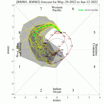
The favorable phases for tropical development centers around Phases 8 and 1. As you can see the MJO is currently in 6 and will go to 7 this week. By Day 7 (June 4) we will have likely navigated through 7 and entering into 8.
Looking at the current view of the tropics, we do have a hurricane (Agatha) currently in the Eastern Pacific off Mexico. Agatha will move northeast over the next five days.


One of the synoptic setups we look at for tropical development lies south of a 500mb ridge. Looking at the setup going into next weekend a ridge will form over the Midwest over to the Mid Atlantic, meanwhile heights are lower across the Gulf of Mexico.
With any potential leftover of Agatha moving northeast into the Gulf it may run into a favorable environment for regeneration.

Looking at ensemble data, there is a little support for tropical cyclone development next weekend focused around the Yucatán.

Discover more from Foothills Weather Network
Subscribe to get the latest posts sent to your email.