
Lead Forecaster Daniel Crawley
Good Sunday evening to everyone, hope your weekend has been a great one. We are about to begin a new week but unfortunately the stout heat and stifling humidity is going nowhere.
What will be happening is an increased chance for afternoon and evening thunderstorms.
An elongated trough over the northern tier of the country will try to squash the Sub-tropical ridge over the Southeastern US but it’s likely to hung up somewhere close to the Interstate 40 Corridor through a large part of the workweek. Looking at tonight’s infrared satellite there is a west-east orientation to the clouds across the Ohio Valley and Midwest.

The approaching boundary will be able to work on some unstable air in the atmosphere. As you can see on Monday and Tuesday CAPE values are running in the 1000-2500 range which is plenty enough thunderstorm fuel.


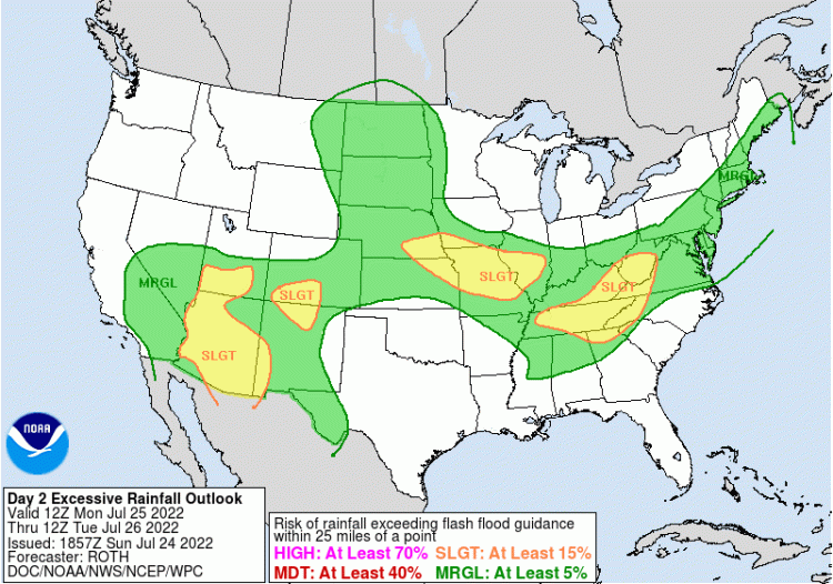
Here’s a look at latest short range guidance and how storms may evolve between Monday morning and Tuesday evening.
Precipitable Water Values of around 2 inches will allow an excessive rainfall threat in areas where repeated storms occur. The WPC has outlooked the Western Carolinas in a slight risk for Monday and with a marginal risk for Tuesday.
If you have outdoor plans the next few days be “weather aware”. Not all areas will get storms but those who do, they could become on the feisty side.
If you haven’t already Download the Foothills Weather App for your device!
The locations that remain dry will continue to see afternoons near or above the 90 degree mark during the first half of the workweek and warmer thereafter. 🥵